Orani
Philippines /
Central Luzon /
Hermosa /
World
/ Philippines
/ Central Luzon
/ Hermosa
World / Philippines / Bataan / Hermosa
town, municipality, third-level administrative division

Municipality of Orani, Province of Bataan
Land Area: 64.90 km²
ZIP Code: 2112
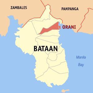
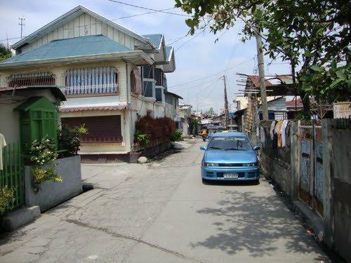
Orani is a coastal municipality in the province of Bataan in the Philippines. It had a population of 61,099 people as registered in the 2010 Census.
The municipality is located 115 kilometers northwest of Manila, and is bounded on the north by Hermosa, on the south by Samal, on the west by Dinalupihan and on the east by the Manila Bay.
It has a total land area of 5,926.00 hectares covering 29 barangays. About 1,231 hectares are used for agriculture, 1,943.86 hectares are forestland, 971.93 hectares are forest reservation and 1,295.91 hectares are reserved for the National Park. The rest are classified as wetland.
Orani is administratively subdivided into 29 barangays:
-Apollo
-Bagong Paraiso (Poblacion)
-Balut (Poblacion)
-Bayan (Poblacion)
-Calero (Poblacion)
-Centro I (Poblacion)
-Centro II (Poblacion)
-Dona
-Kabalutan
-Kaparangan
-Maria Fe
-Masantol
-Mulawin
-Pag-asa
-Paking-Carbonero (Poblacion)
-Palihan (Poblacion)
-Pantalan Bago (Poblacion)
-Pantalan Luma (Poblacion)
-Parang Parang (Poblacion)
-Puksuan
-Sibul
-Silahis
-Tagumpay
-Tala
-Talimundoc
-Tapulao
-Tenejero (Poblacion)
-Tugatog
-Wawa (Poblacion)
MyBataan Webpage: www.mybataan.com/content/view/67/245/
Oranians Website: www.orani.org/main/
Land Area: 64.90 km²
ZIP Code: 2112
Orani is a coastal municipality in the province of Bataan in the Philippines. It had a population of 61,099 people as registered in the 2010 Census.
The municipality is located 115 kilometers northwest of Manila, and is bounded on the north by Hermosa, on the south by Samal, on the west by Dinalupihan and on the east by the Manila Bay.
It has a total land area of 5,926.00 hectares covering 29 barangays. About 1,231 hectares are used for agriculture, 1,943.86 hectares are forestland, 971.93 hectares are forest reservation and 1,295.91 hectares are reserved for the National Park. The rest are classified as wetland.
Orani is administratively subdivided into 29 barangays:
-Apollo
-Bagong Paraiso (Poblacion)
-Balut (Poblacion)
-Bayan (Poblacion)
-Calero (Poblacion)
-Centro I (Poblacion)
-Centro II (Poblacion)
-Dona
-Kabalutan
-Kaparangan
-Maria Fe
-Masantol
-Mulawin
-Pag-asa
-Paking-Carbonero (Poblacion)
-Palihan (Poblacion)
-Pantalan Bago (Poblacion)
-Pantalan Luma (Poblacion)
-Parang Parang (Poblacion)
-Puksuan
-Sibul
-Silahis
-Tagumpay
-Tala
-Talimundoc
-Tapulao
-Tenejero (Poblacion)
-Tugatog
-Wawa (Poblacion)
MyBataan Webpage: www.mybataan.com/content/view/67/245/
Oranians Website: www.orani.org/main/
Wikipedia article: http://en.wikipedia.org/wiki/Orani,_Bataan
Nearby cities:
Coordinates: 14°47'45"N 120°28'54"E
- Subic 44 km
- Capas 75 km
- Botolan 82 km
- San Jose 90 km
- Candelaria 119 km
- Mangatarem 123 km
- Santa Cruz 137 km
- Mabini 164 km
- Bokod 201 km
- Kayapa 204 km
- prospected farm 1.7 km
- 5A Farms - Sibul 3.4 km
- Poblacion (Hermosa) 3.9 km
- ONE MIG farm 3.9 km
- la cumbre land inc. nazareno 5.2 km
- Hermosa Ecozone Development Corporation 5.5 km
- Hermosa Solar Field 5.5 km
- Fiesta Communities Hermosa 7.5 km
- Bataan 14 km
- Pampanga 32 km
Comments