Help

Roraima Tepui

  • Grade context: US
  • Photos: 1
  • Aka: Monte Roraima
  • Aka: Mount Roraima

Description

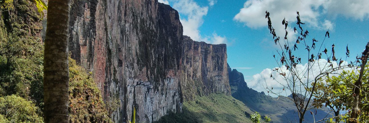
Mount Roraima is the highest of the Pakaraima chain of tepui plateaus in South America. First described to Europeans by the English explorer Sir Walter Raleigh during his 1595 expedition, its 31-square-kilometre (12-square-mile) summit area is bounded on all sides by cliffs rising 400 metres (1,300 ft). The mountain also serves as the tripoint of Venezuela, Guyana and Brazil. Raleigh learned about it from indigenous peoples, who lived there before the European invasion of the 15-1600's.

The only non-technical route to the top is the Paraitepui route from Venezuela; any other approach will involve climbing gear. Mount Roraima has been climbed on a few occasions from the Guyana and Brazil sides, but as the mountain is entirely bordered on both these sides by enormous sheer cliffs that include high overhanging (negative-inclination) stretches, these are extremely difficult and technical rock climbing routes. Such climbs would also require difficult authorizations for entering restricted-access national parks in the respective countries.

Source Wikipedia

Access issues

In Brazil the Monte Roraima National Park lies within the Raposa Serra do Sol Indigenous Territory, and is not open to the public without permission.

History

History timeline chart

Although the steep sides of the plateau make it difficult to access, it was the first recorded major tepui to be climbed: Sir Everard im Thurn walked up a forested ramp on 18 December 1884 to scale the plateau, the route also used by the Clementis in their climb of 15 January 1916. It is currently one of the most important mountain trekking routes in Venezuela, visited by people from many places in the world.

The 2013 Austrian documentary Jäger des Augenblicks - Ein Abenteuer am Mount Roraima (Moment Hunters - An Adventure on Mount Roraima) shows rock climbers Kurt Albert †, Holger Heuber, and Stefan Glowacz climbing to the top of Mount Roraima from the Guyana side. Similarly, in 2010 Brazilian climbers Eliseu Frechou, Fernando Leal and Márcio Bruno opened a new route on the Guyanese side, climbing to the top in 12 days of a very difficult vertical wall climb. They called the new route Guerra de Luz e Trevas (Portuguese for "War of Light and Darkness") and classed it as 6° VIIa A3 J4. A 28-minute Vimeo video called Dias de Tempestade (Days of Storm) documents their climb (English subtitles, audio in Portuguese).

Source Wikipedia

Information needed

This crag does not have approach information. Could you describe the approach to this crag?

If you can help provide a better quality resource for the climbing community then please click 'edit this crag' button near the top of the page.

Accommodations nearby more Hide

Share this

Tue 2 May
Check out what is happening in Roraima Tepui.

Get a detailed insight with a timeline showing

  • Ticks by climbers like you
  • Discussions of the community
  • Updates to the index by our users
  • and many more things.

Login to see the timeline!

Deutsch English Español Français Italiano 한국어 Português 中文